Strengthening Climate Resilience through Predictive, Community-Led Risk Intelligence
Case at a Glance
Impact
~1,00,000
families reached across 10 cities
85–88%
accuracy in predicting heat, flood, and cyclone risks
1,650+
homes insulated, resulting in 8–12°C cooler indoor temperatures
About the organisation
SEEDS (Sustainable Environment and Ecological Development Society) is a not-for-profit organisation working to protect lives and livelihoods through community-led, resilience-based solutions. Since 1994, SEEDS has supported vulnerable communities across disaster risk reduction, climate adaptation, resilient infrastructure, and nature-based solutions, with operations across India and Asia.
Problem Statement
India faces increasing climate and disaster risks from heatwaves and floods to cyclones and earthquakes disproportionately affecting people living in informal settlements. Disaster planning remains reactive and lacks granular, real-time data, making it difficult to identify the most vulnerable households and take early, targeted action.
Solution
SEEDS developed an AI-driven, hyperlocal risk mapping system that integrates satellite imagery, geospatial layers, environmental indicators, and household data to generate building-level, multi-hazard vulnerability scores. The system enables governments and communities to anticipate risks, prioritise interventions, and implement preventive, community-led resilience measures.
Quick Facts
")
Organisation Name
Sustainable Environment and Ecological Development Society (SEEDS)

Organisation Website
Visit Site

Founding Year
1994

Number of Beneficiaries served
12.3 million+ people impacted since inception

Geography Served
23+ Indian states and select Asian countries

Focus Area
Programmatic Impact Operational Efficiency

Functions Impacted
Program Delivery / Beneficiary Services Technology & Data Management

SDG Addressed
Full Case Study
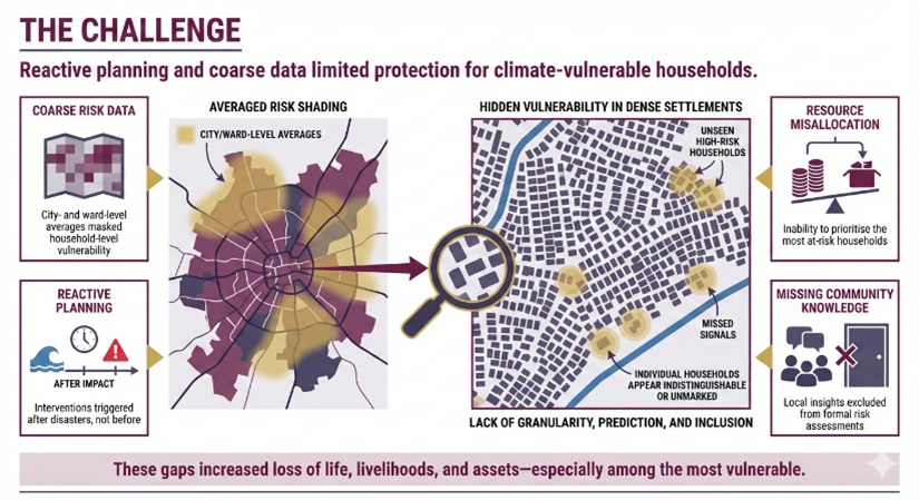
Challenge
Reactive planning and coarse data limited the ability to protect the most climate vulnerable households.
As climate risks intensified, SEEDS observed systemic gaps that limited effective disaster preparedness and climate resilience planning:
Limited Granularity of Risk Data: Existing disaster planning relied on city- or ward-level averages, obscuring household-level vulnerability in dense and informal settlements.
Reactive Planning Approaches: Interventions were typically triggered after disasters, resulting in higher loss of life, livelihoods, and assets.
Exclusion of Community Knowledge: Planning processes often failed to integrate local insights and lived experiences into formal risk assessments.
These challenges underscored the need for an evidence-based, predictive, and inclusive model that could identify climate risks before disasters occurred.
Solution
Predictive, hyperlocal risk intelligence to enable preventive and inclusive climate action.
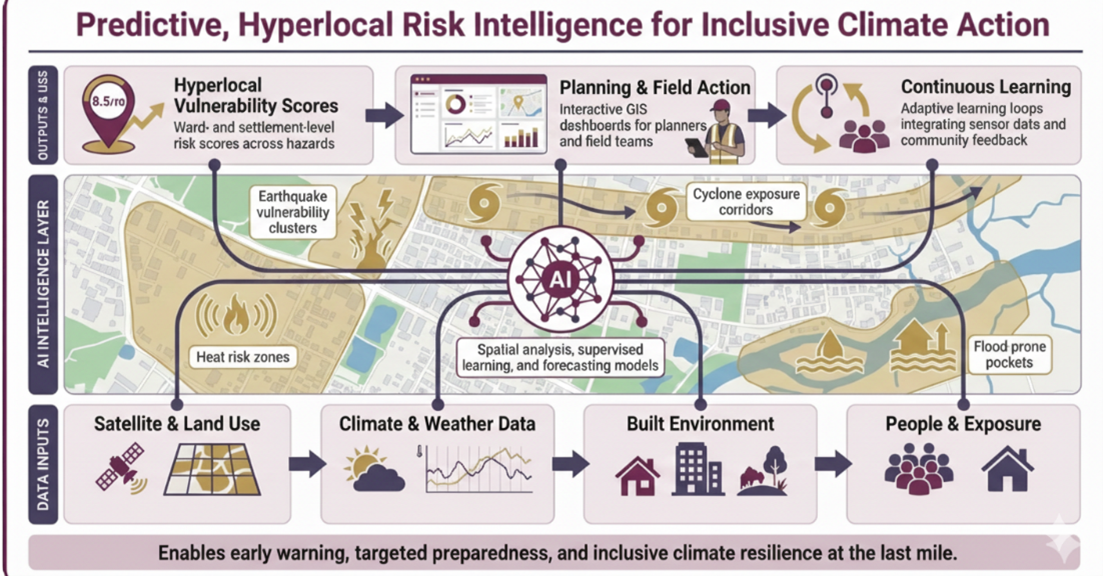
SEEDS built an AI-powered, multi-hazard risk mapping platform that combines:
- Satellite imagery and land-use data
- Meteorological and time-series climate data
- Building footprints, roof types, and vegetation cover
- Population density and household surveys
Using spatial analysis, supervised learning, and forecasting models, the system generates hyperlocal vulnerability scores for heat, floods, cyclones, and earthquakes. Interactive GIS dashboards support planners and field teams, while adaptive learning loops integrate sensor data and community feedback to continuously refine risk assessments.
Outcomes & Impact
From prediction to prevention, translating AI insights into measurable resilience outcomes
- Reached approximately 1,00,000 families across 10 cities including Delhi, Nagpur, Chennai, and Bhubaneswar
- Achieved 85–88% accuracy in identifying multi-hazard risks
- Enabled insulation of 1,650+ high-risk homes, reducing indoor temperatures by 8–12°C
- Improved efficiency of resource targeting by 40%
- Increased community awareness by 72–75% through AI-driven advisories
- Supported integration of AI insights into Heat Action Plans and Flood Preparedness Plans
Technology Stack
| Name of the Tool | Where it was used | What it enabled | Category |
|---|---|---|---|
| Satellite Imagery & Geospatial Layers | Risk mapping | Building-level vulnerability assessment | Open-source |
| Python, TensorFlow, Scikit-learn | Model development | Spatial analysis and supervised learning | Open-source |
| QGIS | Visualisation | Interactive GIS dashboards | Open-source |
| GeoJSON Standards | Data exchange | Interoperable mapping and analysis | Open-source |
| TensorFlow, PyTorch, OpenCV | Model development | Training and deployment of CV models | Open-source |
| OpenStreetMap (planned) | Base imagery | Imagery-agnostic scalability | Open-source |
Key Project Learnings
- Granular data changes outcomes: Building-level risk insights enabled precise targeting, leading to measurable reductions in heat exposure.
- Prediction enables prevention: Shifting from reactive response to predictive planning improved preparedness and reduced downstream losses.
- Community feedback strengthens models: Integrating local inputs improved accuracy, trust, and adoption of AI-driven advisories.
Potential for Wider Adaption
| Sector | Adaptability of the Solution |
|---|---|
| Government Systems | Integration into Heat Action Plans and disaster management systems |
| Urban Local Bodies | Reusable AI backbone for early learning interventions |
| Civil Society Organisations | Community-led climate adaptation and preparedness initiatives |
Additional Details
The information provided here is created as a community resource and is not intended as professional advice or a recommendation by ILSS or Koita Foundation. While we strive to ensure the accuracy of the content, we do not take responsibility for any errors or omissions. Users should use their own discretion before making any decisions based on this information. ILSS or Koita Foundation assume no liability for any actions taken based on the information provided.